A satellite can spot a bridge settling by millimeters—the kind of tiny shift that might take years to show up in a visual inspection. Researchers analyzing 744 bridges worldwide found that adding space-based radar monitoring to traditional inspections cuts the number of structures flagged as high-risk by roughly a third.
The study, published in Nature Communications, reveals something quietly urgent: most of the world's bridges are monitored almost not at all. North America's aging infrastructure—much of it built in the 1960s and now decades past its intended lifespan—ranks among the worst globally. But the real gap is in Africa and Oceania, where traditional bridge inspections are rare or nonexistent. For those regions, satellites could transform infrastructure safety overnight.
Pietro Milillo at the University of Houston and his team used a technology called Multi-Temporal Interferometric Synthetic Aperture Radar (MT-InSAR). It's less intimidating than it sounds: satellites bounce radar signals off bridge surfaces and measure the reflections with extreme precision. The system can detect movements smaller than a few millimeters—the kind caused by slow ground subsidence or the early stages of structural fatigue. Unlike a human inspector visiting twice a year, satellite data arrives constantly and covers entire regions at once.
We're a new kind of news feed.
Regular news is designed to drain you. We're a non-profit built to restore you. Every story we publish is scored for impact, progress, and hope.
Start Your News DetoxWhy This Matters Now
Traditional bridge inspections have a fundamental problem: they're infrequent and expensive. A trained engineer scaling a bridge twice annually can spot obvious damage, but they can't catch the slow, invisible deterioration happening between visits. Structural health sensors—the wired systems that continuously monitor newer bridges—are installed on fewer than 20 percent of the world's long-span bridges, leaving the majority flying blind.
Satellite monitoring doesn't replace these methods. It works alongside them. The researchers found that combining satellite data with existing inspection schedules and sensor networks gives engineers a far clearer picture of a bridge's actual condition. It's like adding dozens of extra inspections per year without sending anyone to the site.
The practical benefit is significant: authorities can prioritize maintenance where it's needed most, rather than guessing based on age or gut feeling. In regions where hiring inspectors is prohibitively expensive or dangerous—think bridges in remote areas or conflict zones—satellites offer a way to keep tabs on critical infrastructure without boots on the ground.
The technology already works. MT-InSAR has been used in academic research for years. What's changed is the evidence: Milillo's team showed that when you feed satellite data into risk assessment frameworks, it actually reduces false alarms and improves decision-making. The European Space Agency's Sentinel-1 satellites and NASA's recently launched NISAR mission both carry the radar systems needed. The infrastructure is there. The data is available. What's missing is adoption.
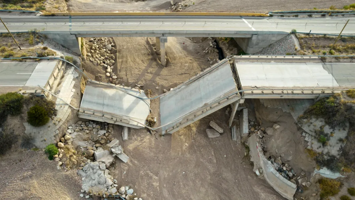
That's beginning to shift. Engineers and infrastructure authorities are starting to realize that waiting for a bridge to fail is far more expensive than monitoring it from space. A bridge collapse doesn't just destroy a structure—it disrupts entire regions, costs billions in emergency repairs, and sometimes costs lives. Catching problems years early, when repairs are still manageable, is the smarter math.
The next phase is integration: getting satellite monitoring routinely woven into the maintenance schedules that actually govern bridge safety decisions. The research provides the proof that it works. The tools exist. What happens next depends on whether the agencies responsible for our bridges decide to use them.