You know the drill: you punch in your destination, and your navigation app spits out a route. Problem is, that route often ignores things like, say, a highway, or the fact that it's 110 degrees and you're about to melt into the pavement.
Well, a team at Arizona State University (ASU) decided enough was enough. They've cooked up a new tool called Cool Routes, and it's here to save you from becoming a human puddle.

Sweat Smarter, Not Harder
Cool Routes isn't just looking for the shortest path; it's looking for the coolest. It calculates how much sun and heat you'll actually feel, using something called "mean radiant temperature." Think of it as the real-feel temperature, but specifically for how much heat is radiating onto your body from the sun, the pavement, and even that brick building across the street.
We're a new kind of news feed.
Regular news is designed to drain you. We're a non-profit built to restore you. Every story we publish is scored for impact, progress, and hope.
Start Your News DetoxIn Phoenix, that mean radiant temperature can hit a scorching 150 degrees Fahrenheit in direct sun, while just a few feet away in the shade, it can drop below 100. Cool Routes updates its data hourly, factoring in weather forecasts, buildings, and — crucially — trees. Because apparently, shade is still the OG air conditioning.
Ariane Middel, who heads up ASU's SHaDE Lab (yes, that's really what it's called, and we love it), explains that the web-based tool lets users pick a start and end point on the ASU Tempe campus. Then, it maps out routes that minimize heat exposure. It looks like a normal map, but with a thermal overlay, essentially asking, "What's the least-sweaty way to get there?" instead of just "What's the fastest way to get there?"
They put Cool Routes to the test for 12 days across different seasons, and it found cooler routes over 70% of the time, even when heat differences were subtle. These cooler paths reduced the perceived heat by about 4.5 degrees on average. Which, if you've ever walked across a sun-baked campus, is a lot.
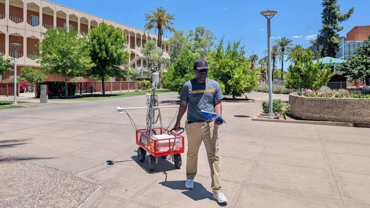
To ensure their heat estimates weren't just wishful thinking, the team deployed a rolling instrument named MaRTy. Because of course, it was. MaRTy measures human thermal exposure with impressive accuracy, helping the researchers confirm their data. Middel and her colleagues published their findings in the journal Building and the Environment.
Turns out, you don't always need to take a massive detour to find relief. A slightly longer path can offer significantly more shade than the direct route. Waqar Khan, an ASU computer scientist, confessed he'd happily walk an extra 10 minutes for more shade and UV protection. The app, wisely, shows both the shortest and the coolest options, complete with length, estimated time, and expected heat exposure. So you can make your own informed, non-melty decision.

While it's currently limited to ASU's Tempe Campus, the method is ripe for expansion into other cities. Imagine city planners using this data to figure out the best places for shade structures, or even to simulate future cooling strategies. The team, including computer science student Fletcher Emmott, is already planning a mobile app version for Emmott's honors thesis. Because apparently, the future of navigation isn't just about getting there — it's about getting there without needing a shower immediately afterward.