Researchers have mapped a crisis unfolding beneath the mountains that supply water to nearly two billion people. Using two decades of satellite data and AI analysis, scientists from the Chinese Academy of Sciences discovered that High Mountain Asia—the "Asian Water Tower"—is losing groundwater at roughly 24.2 billion tons per year.
The scale is abstract until you think about what it means on the ground: farmers in the Ganges, Indus, and Amu Darya basins are pumping water from aquifers that aren't refilling fast enough. The study, published in Environmental Research Letters, reveals that two-thirds of the region experienced groundwater storage declines between 2003 and 2020, with the steepest drops in densely populated agricultural areas downstream.
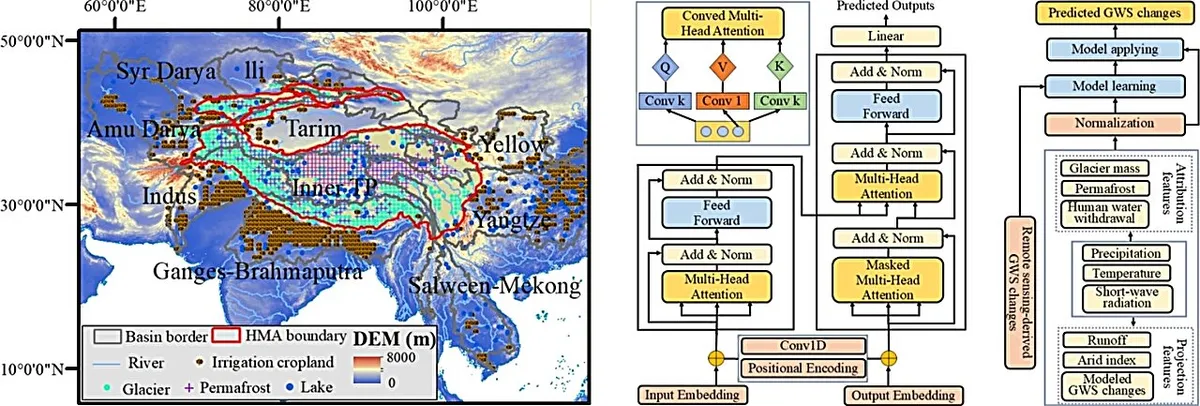
What's Actually Driving This
The research team didn't just measure the problem—they used explainable AI to untangle why it's happening. Climate matters: changes in the cryosphere (glaciers, snow, permafrost) account for nearly half of the groundwater variability. But here's the harder part: human water use, especially irrigation, has become the dominant force pushing depletion faster, particularly after 2010.
We're a new kind of news feed.
Regular news is designed to drain you. We're a non-profit built to restore you. Every story we publish is scored for impact, progress, and hope.
Start Your News DetoxThis isn't a distant problem. When groundwater depletes in the Indus basin, it affects irrigation for 180 million people downstream in Pakistan. When it drops in the Ganges-Brahmaputra system, it ripples through agriculture across India and Bangladesh. These aren't abstract statistics—they're the difference between a harvest and a failed season.
The researchers modeled what happens next under current practices, and the trajectory is grim. Glacier melt might temporarily slow losses around the 2060s—a brief reprieve as mountains release stored water. But that buffer won't last. Once the glaciers shrink further, the decline accelerates, leaving downstream agricultural zones increasingly vulnerable.
Why This Matters Now
What makes this study notable isn't just the warning. It's the method. By combining satellite gravity measurements, Earth system models, and AI that can explain its own reasoning, the team created a tool for understanding groundwater loss at a scale that's actually useful for policy. You can't fix what you can't measure clearly, and for decades, groundwater depletion in mountain regions was largely invisible.
The study doesn't offer easy solutions—it doesn't have to. It does something more useful: it shows exactly where the problem is worst and what's driving it. That's the foundation for the harder work ahead: rethinking irrigation practices, investing in water-efficient agriculture, and managing aquifers as finite resources rather than infinite reserves.
The next decade will determine whether downstream communities can adapt water use before the aquifers cross into irreversible decline.