Scientists have mapped the invisible architecture beneath the Marmara Sea that could determine when and where the next major earthquake strikes along Turkey's North Anatolian Fault — a discovery that brings Istanbul and millions of people living nearby closer to knowing what's coming.
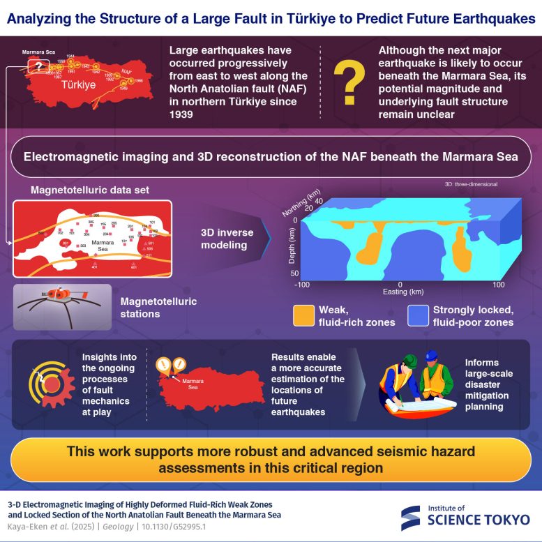
The research, led by Dr. Yasuo Ogawa at Tokyo's Institute of Science and Dr. Tülay Kaya-Eken at Boğaziçi University in Istanbul, used electromagnetic sensors deployed across the seafloor to peer down tens of kilometers into the crust. What they found was a patchwork of strong, locked zones interspersed with weaker sections — and the boundaries between them are where ruptures are most likely to begin.
How They Saw Underground
Over 20 magnetotelluric stations recorded subtle shifts in Earth's magnetic and electric fields caused by deep rock structures. These measurements were then reconstructed into the first full 3D model of the region's electrical resistivity — essentially creating a three-dimensional portrait of what's solid and what's fluid-filled beneath the waves.
We're a new kind of news feed.
Regular news is designed to drain you. We're a non-profit built to restore you. Every story we publish is scored for impact, progress, and hope.
Start Your News DetoxElectrical resistance tells a story. Where rock conducts electricity poorly (low resistivity), fluids like water are present, making that section mechanically weaker. Where resistance is high, the rock is drier, stronger, and locked under enormous stress. The team found distinct zones of each, arranged in a complex mosaic.
"We believe the resistive anomalies observed signify regions of stress accumulation," Ogawa explains. The critical insight: earthquakes along the North Anatolian Fault don't rupture randomly. They nucleate at the boundaries where weak zones meet locked ones — where the mechanical mismatch is greatest.
This matters because Istanbul sits directly above this fault system. A major earthquake here would affect millions. Knowing where ruptures are most likely to initiate gives disaster planners, engineers, and emergency responders a clearer picture of risk. It's not prediction in the sense of saying "it will happen on Tuesday" — earthquake timing remains elusive — but it's something more useful: knowing the geometry of danger.
The study, published in Geology in 2025, represents the first time researchers have mapped this fault zone in three dimensions using electromagnetic imaging. Continued work of this kind could eventually help reduce casualties and damage when the next major earthquake strikes.