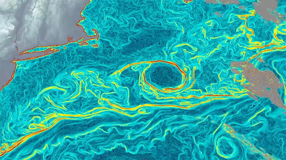
Turns out, those weather satellites we've had circling Earth for ages? They've been hiding a secret. Scientists just taught an AI to peek behind the curtain of thermal images and reveal ocean currents in excruciating, beautiful detail. It's called GOFLOW, and it's basically giving us a real-time GPS for the planet's vast, watery conveyor belts.
Imagine getting a constant, hourly update on every eddy, every swirl, every unseen river flowing beneath the surface. That's what GOFLOW is promising, all without launching a single new piece of hardware into space. Because apparently, the data was there all along, just waiting for a smart algorithm to make sense of it.
The Unseen Ballet Beneath the Waves
Ocean currents are the planet's unsung heroes. They're the global movers of heat, carbon, and nutrients, quietly orchestrating everything from marine life hotspots to your local weather forecast. They're also crucial for tracking disasters like oil spills and even guiding search and rescue missions.
We're a new kind of news feed.
Regular news is designed to drain you. We're a non-profit built to restore you. Every story we publish is scored for impact, progress, and hope.
Start Your News DetoxBut here's the rub: they're notoriously difficult to map. Older satellites might give you a snapshot every 10 days, which is about as useful as checking your social media once a fortnight. Ships and radar offer high-res views, but only for tiny patches. This meant scientists were largely blind to the ocean's quick, dynamic dances — especially the vertical mixing that brings deep-sea nutrients to the surface or pulls carbon into the abyss.
The lightbulb moment arrived in 2023. Luc Lenain, from UC San Diego's Scripps Institution of Oceanography, was staring at thermal images from the GOES-East weather satellite. This thing takes pictures every five minutes. He noticed that major currents, like the mighty Gulf Stream, were subtly etching themselves into these temperature patterns. Bingo. What if those subtle shifts weren't just temperature, but a signature of the current itself?
Teaching a Robot to Read the Tides
So, the team built a neural network. They fed it high-resolution ocean simulations, essentially showing it how water speeds make temperature patterns bend and stretch. The AI then learned to translate these thermal time-lapses into hourly current maps. It's like teaching a robot to watch a cloud of smoke and tell you exactly which way the wind is blowing.
To ensure it wasn't just making things up, they cross-referenced GOFLOW's output with actual ship measurements from the Gulf Stream. The results? A match. Not just any match, but one that revealed far more detail than previous methods, especially for those smaller, faster-moving eddies that tend to get smoothed over.
Lenain says this new method is a game-changer for understanding how the ocean absorbs heat and carbon. We can now see these crucial, small-scale currents in real-time, verifying theories that were previously confined to computer models. Which, if you think about it, is both impressive and slightly terrifying in its implications for climate science.
Since GOFLOW piggybacks on existing satellites, there's no need for a multi-billion dollar launch. It could eventually be integrated into our everyday weather forecasts, improving everything from marine debris tracking to predicting how air and sea interact. The main hurdle? Clouds. They tend to get in the way of thermal images. But the team is already working on combining different satellite data to fill those gaps. They've even made their data public, because apparently, sharing is caring, even when you're unlocking the ocean's deepest secrets.