A swarm of nearly invisible earthquakes is rewriting what scientists thought they knew about one of North America's most dangerous fault zones.
Beneath the coast of Humboldt County, where three of Earth's major tectonic plates collide, something unexpected is happening. For decades, geologists assumed they understood the basic geometry: the Pacific plate slides northwest past the North American plate (creating the San Andreas fault), while the Gorda plate pushes northeast and sinks beneath North America in a process called subduction. Straightforward. Predictable.
Then a magnitude 7.2 earthquake struck in 1992 at a depth far shallower than the model predicted it should be. That discrepancy nagged at researchers. David Shelly at the USGS Geologic Hazards Center in Golden, Colorado, and his team decided to listen more carefully to what the Earth was trying to tell them.
We're a new kind of news feed.
Regular news is designed to drain you. We're a non-profit built to restore you. Every story we publish is scored for impact, progress, and hope.
Start Your News Detox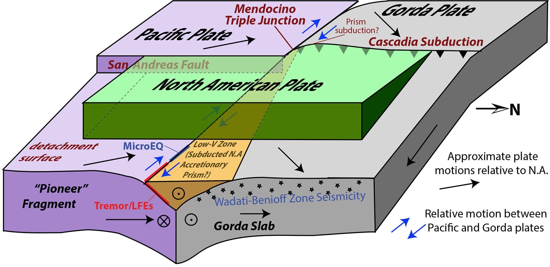
A Hidden Architecture
They focused on something most people never notice: tiny, low-frequency earthquakes that occur where tectonic plates slowly grind past each other. These events are thousands of times weaker than anything a human could feel, but a dense network of seismometers across the Pacific Northwest can detect them. By mapping where these invisible tremors cluster, Shelly's team essentially created an X-ray of the bedrock below.
What emerged was unexpected. Instead of three major plates moving in a tidy arrangement, the region contains five distinct pieces — and two of them are completely hidden beneath the surface.
One is a fragment of the North American plate that has broken off and is being pulled downward alongside the Gorda plate as it sinks. The other is a mass of ancient rock called the Pioneer fragment, a remnant of the Farallon plate that once ran along California's coast millions of years ago. The Pacific plate is now dragging this fragment northward, beneath North America, along a fault that lies nearly flat and invisible from the surface.
Testing with Gravity
To verify their model, the researchers used an ingenious method: they watched how these tiny earthquakes responded to tidal forces. The Sun and Moon don't just pull on ocean water — they exert subtle gravitational tugs on tectonic plates too. When those cosmic forces align with the natural direction of plate movement, the number of small earthquakes increases. This tidal signature acted like a fingerprint, confirming where the plates were actually moving.
The discovery explains the 1992 earthquake's surprising shallowness. The surface being subducted beneath North America isn't as deep as scientists had assumed. "It had been assumed that faults follow the leading edge of the subducting slab, but this example deviates from that," noted researcher Materna. "The plate boundary seems not to be where we thought it was."
This isn't just academic refinement. Understanding the true geometry of these fault zones helps seismologists better assess earthquake depth and risk in a region that sits atop one of the most active subduction zones in North America. The Mendocino Triple Junction remains one of the most seismically complex places on Earth — and now, scientists have a clearer map of what's happening in the darkness below.