Scientists are exploring the Grand Canyon's hidden caves to understand how snowmelt feeds its crucial springs. Their work could help protect the park's water from drought and pollution.
Millions of visitors to Grand Canyon National Park rely on water from Roaring Springs. This cave-fed spring on the North Rim supplies water for people, plants, and animals. As the region gets hotter and drier, protecting this water source is vital.
Researchers at Northern Arizona University (NAU) are studying how these springs work. A new grant from Grand Canyon National Park supports their efforts to map these water systems. They also investigate how snowmelt connects to the springs.
We're a new kind of news feed.
Regular news is designed to drain you. We're a non-profit built to restore you. Every story we publish is scored for impact, progress, and hope.
Start Your News DetoxBlase LaSala, a Ph.D. student at NAU, noted that understanding where water sinks into the ground is critical. These springs are like oases for infrastructure, animals, plants, and ecosystems. Early findings from this project were published in Scientific Reports.
Mapping the Canyon's Hidden Caves
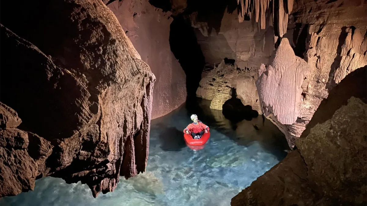
Most people will never enter the caves that feed the Grand Canyon's springs. These caves are closed to the public and often far from trails. Scientists learn about them through special mapping projects.
For his research, LaSala worked with professor Temuulen "Teki" Sankey, a remote sensing expert. They created detailed maps of several cave systems using a mobile lidar scanner. This produced high-resolution 3D models of cave walls, ceilings, passages, and chambers.
Over 45 days, the team documented more than 10 kilometers of underground passages. Sankey was surprised by the size of these caves. She noted that the high-resolution 3D maps are unique and novel for the Grand Canyon.
The work was logistically challenging. Team members carried heavy gear, sometimes hiking for two days to reach remote cave entrances. Inside, they climbed, rappelled, crawled, and even floated through flooded areas. They recorded the caves' shapes and fracture patterns. These details help reveal how water moves through rock layers beneath the canyon.
Following Snowmelt to Roaring Springs
The water in the springs mainly comes from snowmelt on the Kaibab Plateau. The challenge is understanding how this water travels underground to springs like Roaring Springs.
The cave-fed springs are in Redwall and Muav limestone formations. Several rock layers sit between these springs and the surface. Previous dye tracing experiments showed that water can move surprisingly fast through this underground system.
Abe Springer, an NAU professor and project collaborator, worked on these dye tracing studies. In some tests, dye poured into sinkholes on the plateau appeared at springs about 20 kilometers away in as little as a week.
How water moves through the subsurface is still unclear. Factors like fractures, faults, rock permeability, and underground pathways all play a role. Sankey explained that the research connects surface geology to what's thousands of feet below ground. LaSala added that it's like looking at a black box. Now that they know the patterns, they can link data to changes in the springs over time.
Water Quality and Contamination Risks
Understanding these underground pathways is important for water quality and public safety. The Grand Canyon's largest springs are fed by karst systems. Sankey described these as "Swiss cheese" due to their many holes and channels. Water moves quickly through these paths, with little natural filtration.
This means contaminants can also travel fast. Runoff from wildfire burn areas or bacteria like E. coli could enter sinkholes connected to Roaring Springs Cave. If contamination is found, park officials might need to shut down pumping.
By mapping water entry points and pathways, researchers can help managers find contamination sources. This reduces the risk of future water disruptions.
New Research on Snowmelt and Sinkholes
The next phase of the project starts in early 2026. LaSala and Sankey will use airborne lidar surveys and satellite observations from decades past. They plan to map sinkholes on both sides of the Grand Canyon. They will also study snow accumulation and melt patterns over the last 40 years.
This work will mostly focus on surface features. However, researchers are open to exploring newly found caves. The goal is to understand how sinkholes, disappearing streams, and underground water movement are influenced by geology. They will compare surface patterns with those inside caves. These findings will also guide future dye tracing experiments.
Snowmelt is a key focus because Arizona has seen declining snow levels. The Grand Canyon region shows the same trend. The project will create a large archive of environmental data. This data, combined with lidar and other imaging, will improve understanding of regional water systems.
Global Impact of the Findings
This research benefits Grand Canyon National Park, but its importance goes further. Over one billion people worldwide rely on water from karst springs. Better understanding these complex underground systems could help global water management.
The findings may also be valuable for Native American tribes near the park. LaSala finds it exciting to confirm hypotheses made over 50 years ago. He believes many places could benefit from this type of analysis.
How the Dragon Bravo Fire Affects the Study
Researchers expect the Dragon Bravo Fire to impact future observations. They see it as another factor to include in their work, not an obstacle. Sankey called it a "new twist" to their study.
The fire's effects on the Kaibab Plateau will likely change some environmental conditions. These changes will be part of the analysis. The team plans to help the park understand the fire's impacts.
Deep Dive & References
- Three-dimensional characterization of caves within the Grand Canyon’s deep karst aquifer - Scientific Reports, 2025