An underwater volcano eruption north of Papua New Guinea might be creating new land. Satellites are tracking this rare event from space.
Oceanographers often note that the Moon and Mars have more precise maps than Earth's deep seafloor. This is especially true in the Bismarck Sea, a complex area north of Papua New Guinea. It has faults, volcanoes, and active zones that are hard to map in detail.
On May 8, 2026, satellites detected an unexpected underwater eruption in the Central Bismarck Sea. This event highlighted a problem for volcanologists: there were no detailed maps of the area, and the deep-water eruption is not well understood.
We're a new kind of news feed.
Regular news is designed to drain you. We're a non-profit built to restore you. Every story we publish is scored for impact, progress, and hope.
Start Your News DetoxThe eruption is likely happening along Titan Ridge, about 10 miles (16 kilometers) southeast of a 1972 eruption. Scientists are still unsure which volcanic feature is active, how deep the vent was, or when it last erupted.
Jim Garvin, chief scientist at NASA’s Goddard Space Flight Center, noted that satellites offer great chances to explore and learn.
Satellites Reveal the Eruption
The first clear signs were small earthquakes on May 8. Soon after, satellites showed definite signs of an underwater eruption. Starting May 9, NASA’s Aqua and Terra satellites captured images of white, steam-filled volcanic plumes rising into the air.
NASA’s PACE satellite also found discolored, disturbed water around the eruption site. Other satellites saw ash plumes rising several kilometers high. Detailed images from the European Space Agency’s Sentinel 2 and NASA/USGS Landsat 9 on May 10 and 11 showed activity near the ocean surface.
An image of the same area in false color showed the eruption’s infrared signal. On May 12, the VIIRS instrument on Suomi NPP detected heat anomalies spread over about seven square kilometers.
Simon Carn, a volcanologist at Michigan Tech, said there must be a lot of hot material near the surface to create so many thermal anomalies. This suggests a shallow eruption vent, much shallower than existing maps indicate.
A New Island May Form
Satellite images show strong activity in shallow water. There are large areas of discolored water and many steam and ash vents. Sensors from government and commercial satellites have also captured wide pumice rafts, which are floating volcanic rocks, forming long streaks in ocean currents.
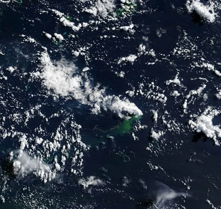 Floating pumice and green, discolored water extend southwest from the eruption site as a white volcanic plume drifts west overhead in this image acquired by the MODIS (Moderate Resolution Imaging Spectroradiometer) on NASA’s Terra satellite on May 15, 2026. Credit: NASA Earth Observatory/Michala Garrison
Garvin is watching to see if a new island will form, which is a rare event to observe with satellites. If new land appears, volcanologists will track its changes. It might grow into a tuff cone with a crater, or it could quickly collapse and erode.
The eruption could also become more explosive if seawater reaches the shallow magma chamber.
Explosive Risk Appears Limited
This eruption has been less explosive than recent underwater eruptions like Hunga Tonga Hunga Ha’apai in 2022 and Fukutoku Okanobain in 2021. Carn believes it's unlikely to become highly explosive. This is because it seems linked to a volcanic ridge near a transform fault and a back-arc spreading center.
Spreading centers usually have less explosive activity. The most explosive eruptions typically happen along subduction zones and involve large stratovolcanoes.
It's unclear how long the eruption will last. The 1972 eruption in the same area lasted only four days. Another eruption about 100 kilometers away in the St. Andrew Strait in 1957 continued for nearly four years.
A Rare Natural Laboratory
Garvin and other scientists are closely watching the eruption. He plans to use radar data from the NASA ISRO NISAR satellite and the Canadian Space Agency’s RADARSAT Constellation Mission. This data will help map any new land and track its shape changes.
If a lasting island forms, Garvin sees a chance for researchers, or "island-nauts," to visit and study it. They could observe how a young island responds to plant and animal colonization, rainfall, and erosion. This would be similar to studies done after the Hunga Tonga Hunga Ha‘apai eruption.
Garvin noted that this new eruption could offer an even better chance for "island-naut" exploration as NASA prepares to return to the Moon with Artemis IV.